Partnered Pony Blog

Posts tagged stage coach
Fort Pierre to Deadwood Historic Trail

Deadwood stagecoach. Courtesy Library of Congress.

My neighbor thought I was nuts when I offered to drive half way across the state of South Dakota to pick up a piece of equipment for him. After all, we had just made that four-hour drive a few days before when taking cattle to a sale. But I had discovered that about half the drive followed an historic stagecoach route, and I had a project there I wanted to do.

My neighbor has been making that drive for many years. It wasn’t until I was with him a few months ago, though, that he learned about the stage route connection. On that day, I noticed a white sign along the road that identified the stage route. And then I noticed another sign. And then another. My curiosity was piqued! I had already been studying a stage route near where we live: the Cheyenne to Deadwood Trail. This newly discovered (for us) trail was from Fort Pierre to Deadwood - Deadwood being a gold mining town beginning in the late 1800s. Fort Pierre, on the Missouri River, was the closest that boats could get to that gold mining district in the Black Hills. From Fort Pierre, stagecoaches took passengers and ox trains took cargo to Deadwood.

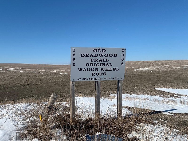
When we passed the first sign on that discovery trip, my neighbor asked how far it might be to the next sign. I guessed 8-12 miles since that’s the typical distance between stage stops, which was determined by the stamina of the horses pulling the stagecoach and the terrain over which they were traveling. But the distance this time was just 2 miles, which is unusual for markers of historic trails.

It turns out that the Fort Pierre to Deadwood trail was very fortunate to have some dedicated fans. In the 1970s, local ranchers Roy and Edith Norman took an interest in ensuring the trail’s history would be remembered. Roy had learned of the trail and its many significant features when riding horseback as a young man. So he and Edith created signs and placed them along the highway with the permission of the landowners. On the signs, they included GPS coordinates that they had surveyed, marking the exact location of the features described on the signs. Volunteers since then have maintained the signs. The signs all face east, for westbound traffic, reflecting the historic flow of people, animals, and goods.

On my equipment hauling day, my project was to photograph all the signs west of Fort Pierre along my route. As it turned out, I only managed to stop and photograph a third of the signs before I ran out of time; you can see them below. Since ranch errands often take us that way, I look forward to finishing the project in the future. A few of the signs that I did take pictures of indicate where the Black and Yellow Trail and the Deadwood Trail cross. The Black and Yellow Trail was a promotional trail inspired by the emerging popularity of the automobile in the early 20th century. The Black and Yellow Trail connected Chicago with the Black Hills and Yellowstone National Park .

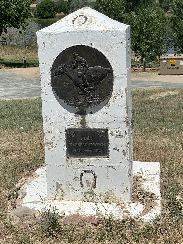
I suspect I have my neighbor thinking differently about features along the route. On that first discovery trip, he asked about a town ahead, wondering if it was founded to support the railroad that paralleled the highway. I smiled and explained that, in my research of various historic trails, what are today highways often follow rail corridors, which often followed stagecoach trails, which sometimes followed Pony Express mail routes, both of which often followed native trails. So the town in question may well have pre-dated the railroad because it was a station on the stagecoach or Pony Express route.

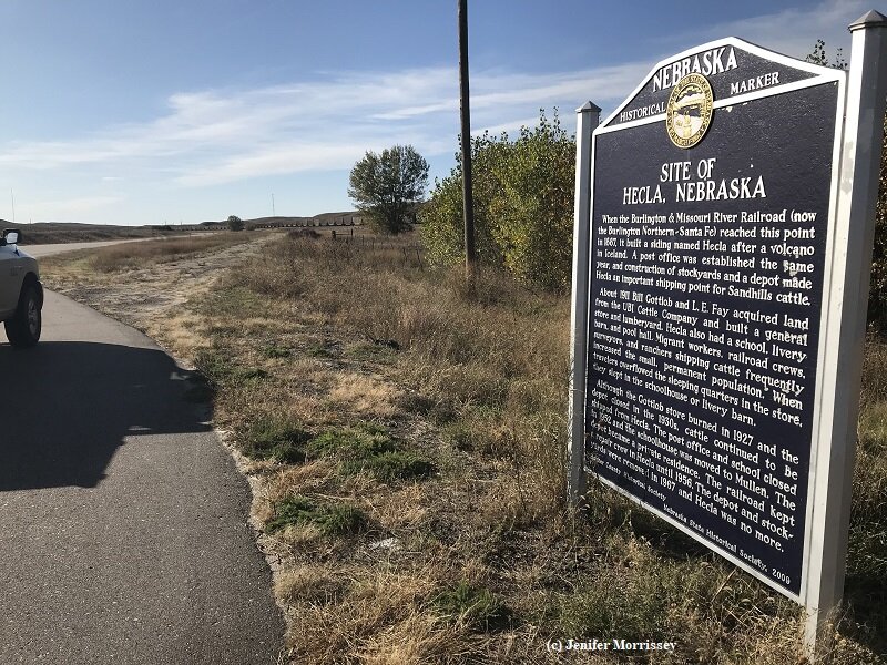
Post offices are indicated by some signs, reflecting that an important early use of the trail was for mail delivery. In addition to the signs along the route marking the Deadwood and Black and Yellow Trails are other privately erected interpretive signs about Native American history. A rich route indeed!

© Jenifer Morrissey, 2022

A Stage Route Nearby

I am intrigued by how my Fell Ponies use the landscape where they live. Four are visible just above the lower trees.

The Fell Pony is in part a landscape-adapted breed. (1) As a Fell Pony steward, then, it’s not surprising that I am intrigued by how Fell Ponies use the landscape where they live. My best mornings are when I wake up and look out the window and see my herd of mares high on the hill that is their pasture, similar to how their ancestors have lived in England on the fells for centuries. The picture here shows one such view.

I am also intrigued by how people use landscapes. That’s why I’m currently writing a series of articles for Rural Heritage magazine on regenerative agriculture. And being so intrigued explains why I am enthralled with the workings of the cattle ranch where I live here in South Dakota.

So I suppose it’s no surprise that I’m especially intrigued by how humans and equines work on landscapes together. Orchard Hill Farm in Ontario, Canada features in several of my regenerative agriculture articles in part because they use their Suffolk Punch draft horses in their market garden. That Suffolks are a rare breed made the stories there even more of interest. (Click here to see pictures on Orchard Hill’s website.) Closer to home, I hope to get my ponies more involved on the cattle ranch where we live. The picture shows when Willowtrail Wild Rose and I encountered a hay trailer recently unloaded while out on a ride.

I am also intrigued by how people interact with landscapes, including on the cattle ranch where we live. A load of hay was recently unloaded from this semi.

I have been blessed to be writing articles for Rural Heritage for many years about draft horse use on farms and to compile an entire book about harness. And I have a series underway in my Fell Pony newsletter about how the ancestors of Fell Ponies participated in the industrial and agricultural past of the region they call home in England. (Click here to read some of the articles.)

A completely different interaction of humans and equines on landscapes was during the stagecoach era. Over the years, I have read about stage coach routes and practices and companies on this continent, in Britain and in Australia. You can imagine then my elation when I learned that an important stagecoach route went within just a few miles of where I now live. This area and places I regularly see when we travel nearby are rich with stage coach history. I made this discovery while researching my articles on regenerative agriculture!

Looking north towards Minnekahta along the Mickelson Trail , a Rails-to-Trails conversion in South Dakota. There is evidence nearby that this railroad followed an old native trail.

When we go to Custer, South Dakota, we go north from the Minnekahta Valley on Highway 89. Highway 89 follows roughly the route of the Mickelson Trail which is an old railroad bed converted to a trail under the Rails to Trails Act. When I heard that a stage route went nearby and north to Custer and on to Deadwood, I wasn’t surprised because over the years I’ve learned that often highways follow rail lines which follow old stage routes and pioneer wagon trails which often follow old native pathways. A picture shows Rose and I looking up the Mickelson Trail, and there is evidence of a native trail nearby. Pony Express routes often paralleled old stage routes, too. We found the marker shown in a photo along the North Platte River when investigating pioneer wagon train routes.

Pony Express routes often paralleled stage routes and pioneer trails. This marker is near a part of the Oregon Trail in Wyoming.

In the course of my education about this area, I had been told about the Metz massacre nearby. But it wasn’t until a Red Canyon resident told his version of the story to me that I realized just how close it was to where I live. So when I had company coming and we were headed to Red Canyon for reasons of regenerative agriculture, I decided to get informed to be a better tour guide. That’s when I learned that the context of the Metz massacre in Red Canyon involved stagecoaches and so much more. For about a year beginning in 1876, the Cheyenne to Black Hills Stage ran through Red Canyon on its way to Custer and Deadwood. The reason was gold fever. The Red Canyon route was eventually abandoned by the stage company, but the route was still used by hopeful migrants. Click here to see a picture of the location of the Metz Massacre taken in 1876, about six months after the tragic event. Rarely do we have photos from this period!

The topography in the area of Red Canyon, with the steep-sided and narrow canyon itself in the mid ground.

The stage company abandoned the route in part because of a shorter route to the west, but also because of Red Canyon’s topography. One passenger described its hair-raising character: “Red Canyon was like a cake cut in two and the pieces shoved back a little. You couldn’t see the sky unless you put your head out of the coach.” (2) A picture here shows the topography of the area with the narrow slot of Red Canyon in the midground. Anyone intent on harming through-traffic had ample places to hide and advantageous positions up on the canyon walls from which to shoot or even just throw rocks to spook stock.

It was the massacre of the Metz family that eventually helped bring military attention to the area. Those responsible for the murders were never found. Some blamed it on Native Americans who certainly had ample reason to be hostile. More on that in the next story. Others say that it was likely the road agents who were active along the route. Just as Border Reivers wreaked havoc in the Fell Pony homeland in their day, road agents did similarly in their day, close to where my ponies now live.

I am grateful to my ponies for teaching me to look at landscapes with new eyes, appreciating how humans and equines have worked together in the past and can still.

  1. The Fell Pony also has a breed description that breeders use in selection of breeding stock, so the breed is also in part a standardized one.

  2. Spring, Agnes Wright. The Cheyenne & Black Hills Stage and Express Routes, p. 138. 2016 abridged and edited edition of the 1949 original.

© Jenifer Morrissey, 2021

Travel Intervals
At O’Fallon’s Bluff in Nebraska, inlaid brick shows the line of Oregon Trail wagon wheel ruts on the ground, with wagon sculptures showing the path across the landscape.

At O’Fallon’s Bluff in Nebraska, inlaid brick shows the line of Oregon Trail wagon wheel ruts on the ground, with wagon sculptures showing the path across the landscape.

My pickup just told me it has been ten thousand miles since I began moving Willowtrail Farm from Colorado to South Dakota.  Some of those miles were also accumulated on my trip to St. Louis and back on a business trip.  I have two trips to Colorado remaining to complete my move, so I will be servicing my truck before them.  As I thought back over those ten thousand miles, I remembered noticing on some routes the regular distances between small settlements, and I smiled with the connections of these travel intervals to ponies and other equines.

The first route where I had that recognition was between Fort Collins, Colorado and Laramie, Wyoming.  I know it was a stagecoach route, so I appreciated the 8-12 mile distances between dots on the map such as Tie Siding, the state line, Virginia Dale, and Livermore.  Those distances were what the teams of horses pulling the coaches could sustainably work at speed.  Today most people whiz by what used to be important stops on overland travel.

On my trip to St. Louis, it was my personal travel interval between rest areas that brought another smile of recognition.  Today the interstate highway through Nebraska follows the Platte River and portions of the Oregon Trail.  One rest area was at O’Fallon’s Bluff, “one of the most difficult and dangerous spots on the trail,” according to the interpretive sign.  The landscape was still marked by wagon wheel ruts, and the spot was commemorated with brick laid to show the line of the ruts.  Wagon sculptures showed the lay of the trail.  The Pony Express, the short-lived horseback deliverer of mail, also went over O’Fallon’s Bluff.

Another rest area, near Lusk, Wyoming, also celebrates its connection to historic stagecoach travel.  It is a particularly beautiful – and well-placed – spot on my numerous journeys between Gould and Hot Springs.  The grave of a renowned stagecoach driver is there.  The interpretive sign says, “Here you stand on the Cheyenne-Deadwood Trail over which freight wagons and stagecoaches traveled between Cheyenne and the Black Hills gold mining area from 1876 to 1887.”  The railroads put an end to stagecoach travel.

The former Hecla, Nebraska on Highway 2 is one of a line of settlements approximately 8-12 miles apart, suggesting a travel interval from the time of equine-powered transport.

The former Hecla, Nebraska on Highway 2 is one of a line of settlements approximately 8-12 miles apart, suggesting a travel interval from the time of equine-powered transport.

Highway 2 across western Nebraska was the most recent route where I noticed travel intervals reminiscent of equine-powered travel.  Though the interpretive sign for Hecla, Nebraska indicated that a rail stop was the raison-d’être of the former town, the travel intervals between settlements on that lonely road certainly suggest an equine-based mode of travel.

The sign at O’Fallon’s Bluff says, “Although the danger and hardships faced by early travelers no longer exist, the Great Platte Valley route remains an important modern thoroughfare across Nebraska and across the nation.”  The same is true for so many of the routes that we now travel at high speeds, rarely noticing how equine (and oxen) powered travel shaped development along the way.

© Jenifer Morrissey, 2019